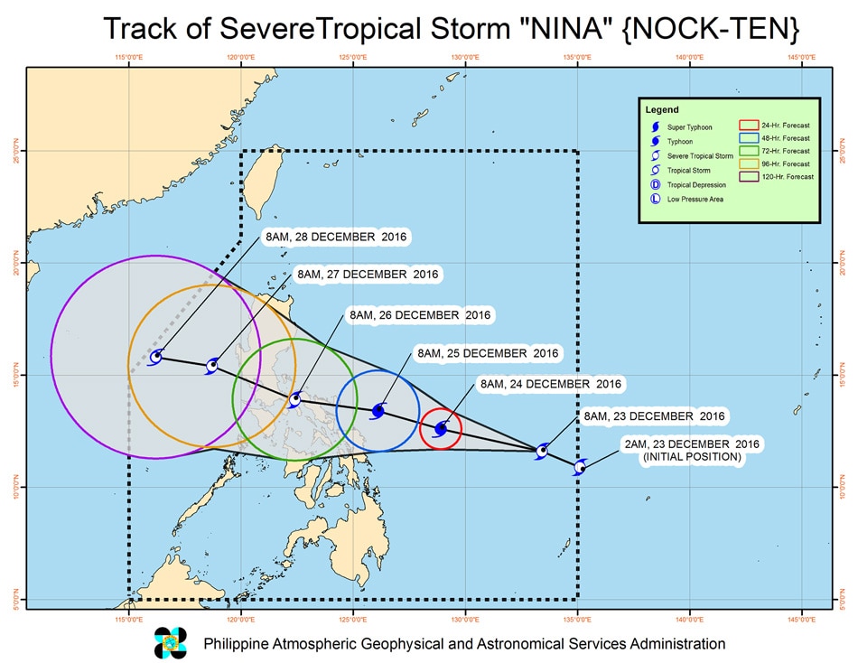
MANILA (UPDATE) – Severe tropical storm ‘Nina’ has entered the Philippine Area of Responsibility (PAR) Friday morning and will affect Metro Manila on Sunday, Christmas Day.
State weather bureau PAGASA weather forecaster Obet Badrina said Metro Manila residents will experience storm’s power on Monday, but will start to feel it from Sunday until Tuesday. Badrina said their forecast so far is “Nina” will reach typhoon category at 130kph. Storm signal number 3 may be raised in certain areas, he added.
“Sa nakikita natin, aabot ito sa typhoon category, around 130 kph. Ibig sabihin, para ma-imagine na mga kababayan natin, hanggang signal number 3, pwedeng magtaas tayo,” he said on radio DZMM.
He advised residents to keep safe especially those in the directly affected areas in Catanduanes. Estimated arrival of Typhoon Nina’s eye will hit the provice around 5 to 8 P.M. on Christmas Day this Sunday.
“Nina” is also expected to make landfall in the Quezon Province and will traverse the regions of CALABARZON, MIMAROPA, and Metro Manila. “Estimated rainfall amount is from moderate to heavy rains within its 350 km diameter of the severe tropical storm,” the latest weather advisory read.
As of today, December 24, Signal number 1 is raised in the following provinces:
- Camarines Norte
- Camarines Sur
- Albay
- Catanduanes
- Sorsogon
- Masbate including Ticao and Burias Islands
- Northern Samar
- Eastern Samar
Aside from the Bicol Region, there will also be stormy weather in Metro Manila, Calabarzon, Bulacan, Pampanga, Bataan, Zambales, Marinduque, Oriental Mindoro, Occidental Mindoro, and Northern Samar from Sunday to Monday, December 26.
Moderate to heavy rain is expected within Nina’s 400-km diameter, which could bring floods and landslides. Strong winds may topple structures and trees, added PAGASA.
The state weather bureau also warned that storm surges are possible in coastal areas in Bicol, Samar, and Quezon. Sea travel is generally risky in Northern Luzon and in the eastern seaboards of Central Luzon, Southern Luzon, and the Visayas.
“Our people are being made aware that we could get hit on Christmas Day,” Romina Marasigan, spokeswoman for the National Disaster Risk Reduction and Management Council, told AFP.
Weather forecaster Badrina said there is a very slim chance that ‘Nina’ would take a different track and be dissolved in the ocean, but it may weaken if it interacts with the northeast monsoon or the mountainous areas.
Nina is expected to leave the Philippine Area of Responsibility (PAR) on Wednesday, December 28.
With reports from abs-cbn.com and rappler.com


